In the high and deep places of the Wuyi Mountains, there is a small stream that is swift and narrow, winding nine turns and eighteen bends, gathering the trickles of the ancient Chong'an County, and entering the wide stretch of the river valley of Jianyang County. Fujianese named this small stream connecting Chong'an and Jianyang Chongyang Creek. After the Chongyang River continued to rush for 53 kilometers, the Songxi River gathered in the upper reaches of the Jianou Gate of the ancient Jianzhou City and became Jianxi...Here, half of the origin of "Fujian" was formed. Above Yanping, within the Beimin River sub-basin in northern Fujian, whether it was the Jianzhou Fu area in the past or the Nanping City area which is almost the same range today, the state capital is located between Chongyang River and Jianxi River. Yang, Jian'ou in the middle reaches and Yanping in the downstream, move back and forth between the three sections. Here you can see that the depth of the waterfront in northern Fujian does not exceed 50 kilometers, which has become the ecological background on which half of Fujianese live and produce.
At the end of 2014, the Hefei Fuzhou section of the Beijing-Fuzhou high-speed rail was opened. Chongyang Creek’s "Tea Rice Zhan" road starts from the uppermost reaches of the North Minjiang River and the small streams between Wuyi Mountains and becomes the front-end gateway area from Beijing and Shanghai to Fujian. In the same year, the Nanping Municipal Party Committee and Government announced that it would move from Yanping, Sanjiangkou, where the industry had severely declined, to Jianyang, the upstream with the richest resources for cultural tourism and farming. History has gone through a big spiral. Therefore, with the promotion of high-speed rail, it is a challenge for the Wuyi Shandong Station project to create a cultural and tourism high-speed rail town by the Chongyang River, highlighting the waterfront and surrounding mountains.
Wuyi New District is an important development area for Nanping City to play the leading role of the central city in northern Fujian and respond to the strategic deployment of the construction of the Haixi Economic Zone. Under the background of developing global tourism as the promotion of economic development, Wuyi East Railway Station, as the "most beautiful high-speed rail" Hefu High-speed Railway, is the largest high-speed rail hub station in northern Fujian, making the East Railway Station area the most important urban growth point in Wuyi New District and shouldering tourism. The dual mission of the gateway and the new high-speed rail area.
The Wuyi East Railway Station area developed and operated by the Fuzhou Luneng Company is located 20 kilometers south of the Wuyi Mountain Scenic Area and 10 kilometers north of Jianyang City by the overall planning and design of Zhubo. After a large amount of data analysis and research and selection of different planning ideas, Zhubo Design assisted Fuzhou Luneng to clarify the design positioning of the pan-sports town, and through various strategies to realize the adjustment from a CBD-type upper-level planning to a green ecology that is livable and suitable for travel Cultural Tourism New District.
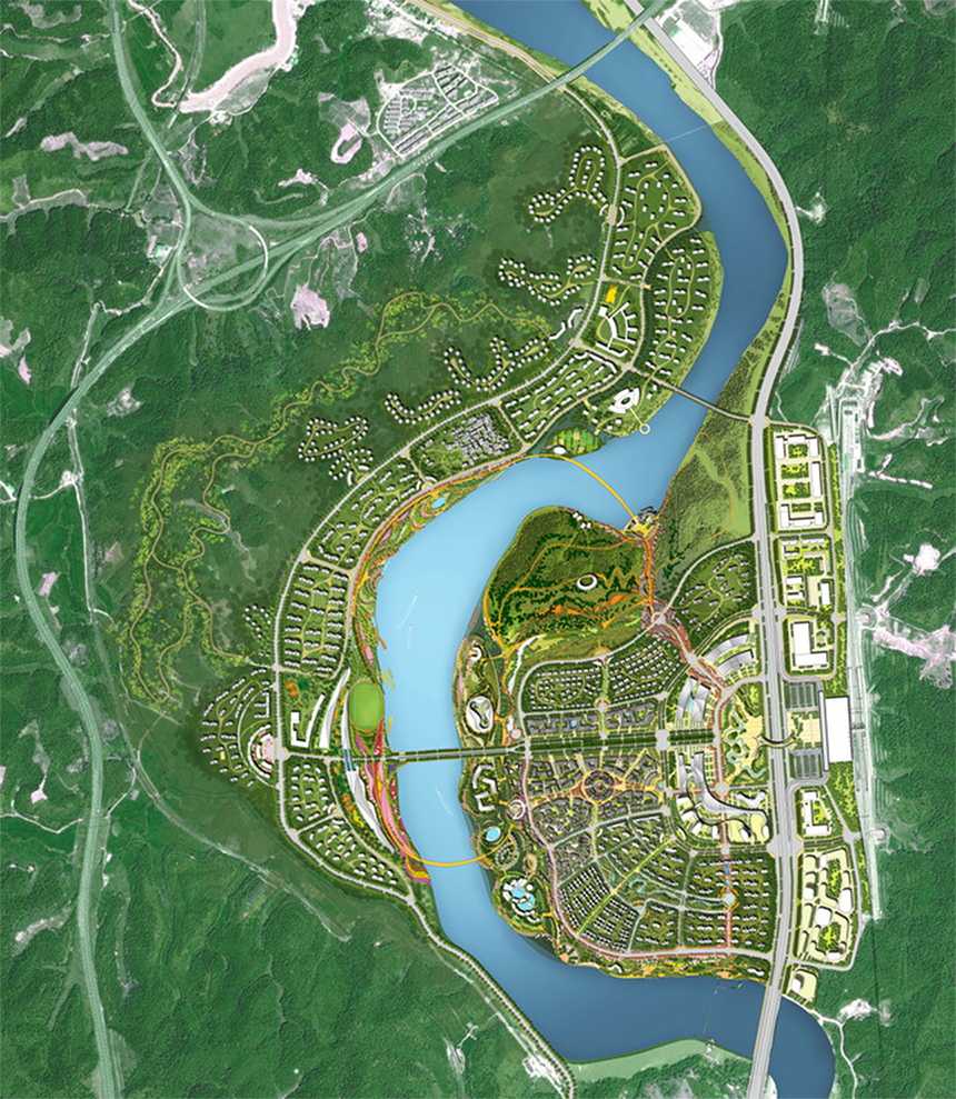
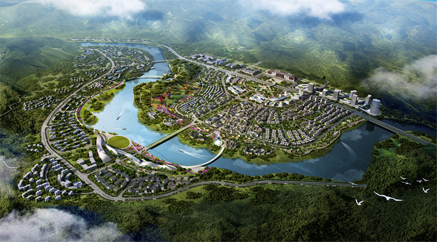
▲General floor plan
The traditional CBD grid planning form is dull, and the urban space form lacks charm, which makes it difficult to realize the demands of tourism portals. Zhubo Design abandons the conventional high-speed rail new city planning idea, and from the perspective of community construction, proposes a development strategy from urban CBD to ecological town: weaving and interspersing construction land and ecological layout, forming a winding and soft ecological town pattern . In terms of format positioning, it absorbs regional culture and combines the advantages of Luneng's sports industry to create a strong interactive town with "tourism + culture + sports" as the bright line, seeking a modern experience mode of northern Fujian culture, and activities as the leading; "Tourism + physical industry" is the end display, linking industrial resources, multi-industrial clusters, and multi-dimensional cross-border display; "Tourism + industry drives livable and slow life" through the spatial form basis of ecological towns, sharing advantages and activating the area.
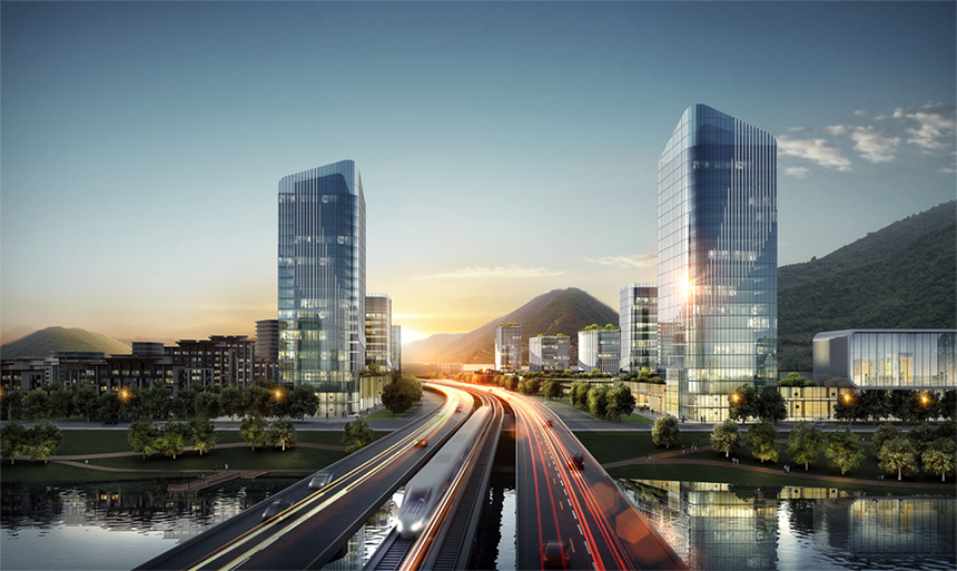
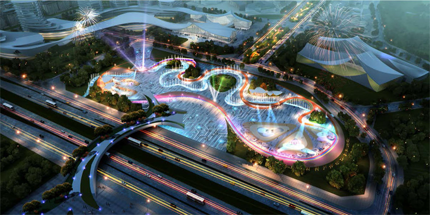
▲A bird's-eye view in front of the high-speed rail station
Chongyang Stream flows through the Wuyi East Station area, creating a 5-km-long waterfront potential area. On the other hand, the currently separated two banks are only connected by a two-way six-lane bridge. Therefore, the design focus is to tap the potential of nature and promote the atmosphere of cultural tourism. Firstly, the sports experience and cultural tourism attraction projects are laid out along the waterfront; secondly, two slow bridges are added to connect the waterfront area into a loop, so that the experience flow line forms a closed loop; finally, on this basis, the urban green corridor is directed to the waterfront, The visual corridors are echoed, the green corridors are intertwined, the migration path is accessible, and the public accessibility of the waterfront is maximized, thereby creating a rich and vibrant waterfront ecological environment.
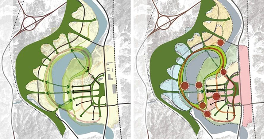
▲Waterfront ecological vitality ring
▲Lehas Waterfront
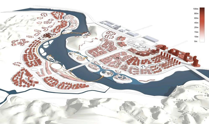
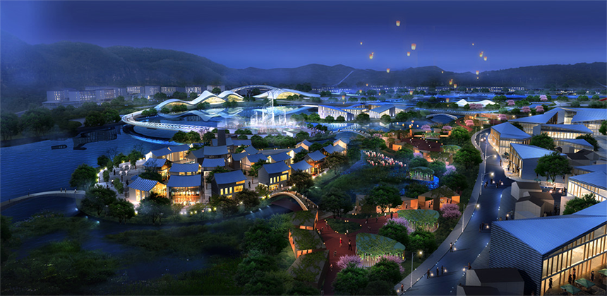
Scale control-Castle Peak half into the city
The construction of the image area in front of the station follows the principles of pragmatism, gradual progress and rationality, and reasonable control of its scale and form at the planning level. Decrease the total amount of commercial and commercial land, and control buildings of 50m~100m to avoid the area in front of the station, retain the current mountain to the greatest extent, open up the sight corridor from the front of the station to the mountain, avoiding the same image of the station in front of high-rise buildings. Preserve the ecological background color for the tourism portal of Wuyi.
Heritage
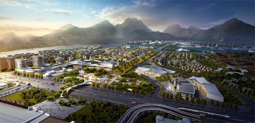
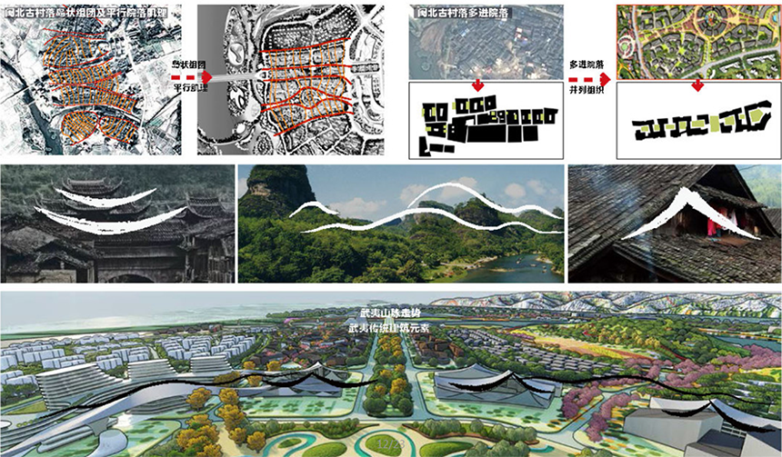
The cultural tourism core block draws on the island-like clusters and parallel textures of traditional ancient villages in northern Fujian, retains the spatial pattern of multi-entry courtyards side-by-side organization, and creates a block space with local cultural attributes. The image display belt in front of the station is composed of public buildings such as the Great Wuyi Visitor Center, industrial exhibitions, and trade exhibitions. It is extracted from the characteristic Danxia landform of Wuyi area and the positive and negative arc curves of the eaves of traditional buildings in northern Fujian to form a landmark building group. Create a unique outbound first impression to increase regional characteristics.
Pan-sports atmosphere
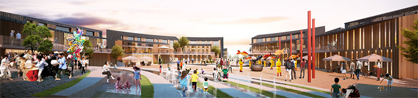
From the planning structure level, diversified public spaces are reserved to carry various sports activities and events, and the pan-sports lifestyle is supported from the aspects of business format, landscape atmosphere and facilities. The sports environment landscape control follows the following principles: rich venue types, friendly ground materials, venues and trails surrounded by tall trees, gentle slopes and undulating inclusive landscapes, and brightly colored venues inspire sports emotions.
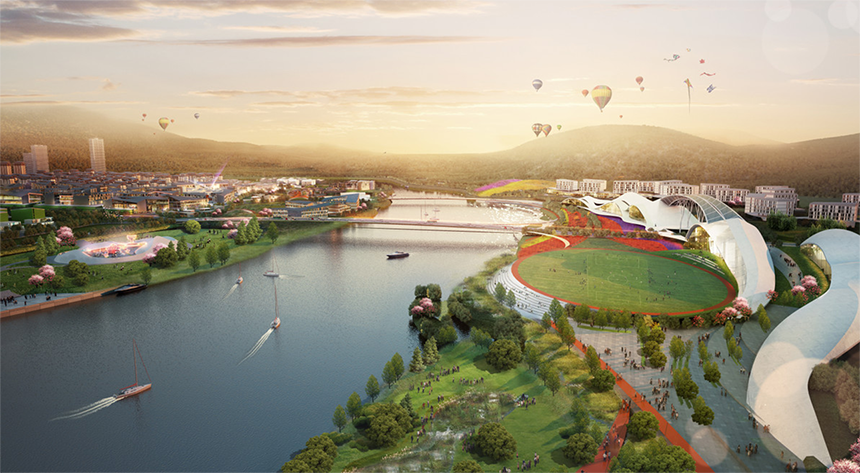
▲Sports Town Fashion Plaza in front of the station
Ecological road section
On the basis of not changing the traffic capacity of the original plan and design, optimize the design of the road section. The green belts on both sides of the celebration avenue in front of the station are merged into the center of the road to avoid the excessively wide green belt from separating the road and the commercial interface. At the same time, a 20m-wide belt-shaped central celebration park is reserved for the celebration activities to provide for the marathon celebration and the daily life of the citizens. place. Branch roads and small roads within the lot pay attention to the control of the road height-to-width ratio, increase the undulating landscape landscaping, and create a close-to-human-scale green urban space.

▲Road reconstruction
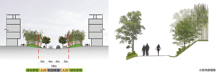
▲Ecological road section
Ecological rain flood
The design adopts the principle of low-impact development. The original hard embankment is several meters higher than the construction land, which has poor effect and hinders the creation of waterfront atmosphere. Planning suggestion: On the basis of earthwork balance, local low-lying areas are set up as flood buffers, and relatively low-lying areas are also used as rainwater parks, so that most of the surface runoff will be fully infiltrated and purified before entering Chongyang Creek. Set up island-like construction land in the area above the waterproof level in the rainwater park to resolve vertical problems, and allow more plots to have waterfront interfaces and sight lines, so that the ecological atmosphere becomes the basis for the growth of various waterfront businesses.
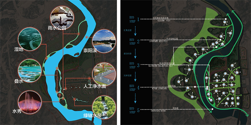
▲Waterfront ecological restoration and landmark runoff purification system
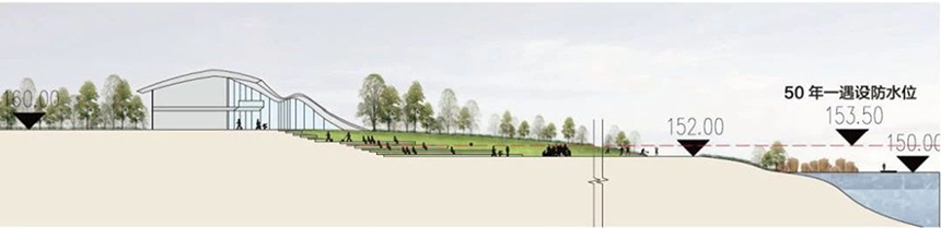
▲The softening of the landscape embankment
The northern part of Fujian has unique cultural characteristics: the richness of regional culture with one place and one custom; the natural abundance brought by the emphasis on culture and agriculture, and the elegant temperament of the world; the geographical characteristics of northern Fujian have long since moved to the south of the Central Plains Han people many times, becoming a refuge A turbulent blessed land; rich religious heritage represented by Dasheng culture. Based on the above characteristics, a magical, rich, and out-of-the-world atmosphere is extracted to create a cultural experience place with regional characteristics in northern Fujian.
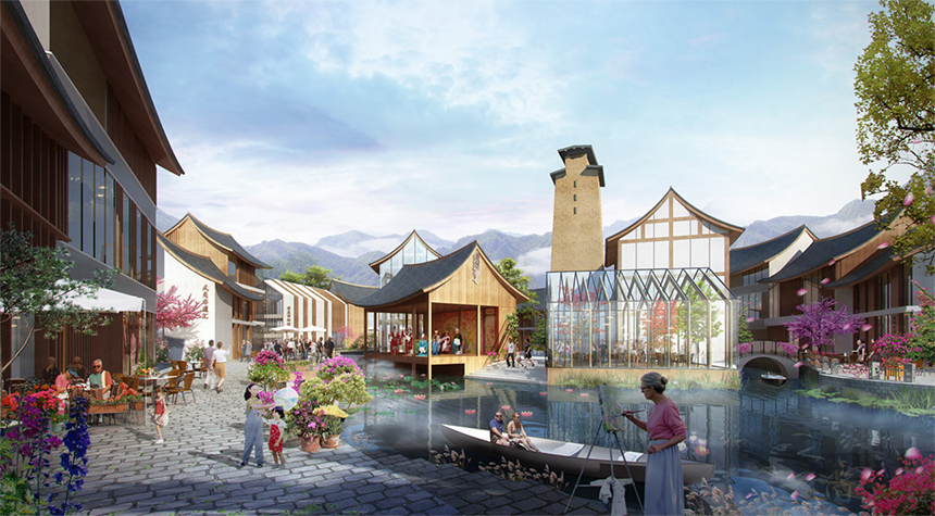
▲Cultural Experience Site of Northern Fujian
▲Gathering place for participatory cultural activities
The design of the pan-sports town of Wuyi East Railway Station is not only a creation of the construction of an ecological high-speed rail new area in the era of high-speed rail tourism, but also an on-site exploration of the construction of waterfront communities in the hilly area of northern Fujian, emphasizing the interaction between man and nature from the macro to the micro. Paying attention to how nature is perceived by people, paying attention to the accessibility of public green open spaces, and creating a charming small-town community based on ecology is our goal.
Design company: Zhubo Design Co., Ltd.
Project address: Nanping City, Fujian Province
Planning area: 6.43 square kilometers
Construction land: 2.0343 million square meters
Design year: 2017
Project status: under design
Project owner: Fuzhou Luneng Real Estate Co., Ltd.
Project Chief Designer: Zhang Xiaoyi
Project Chief Planner: Li Tao
Project design team: Ming Ye, Guo Yansheng, Liu Kai, Zhang Yao, Liu Rongting, Li Bo, Teng Xiaotong, Lu Feiyang, Shen Lu, Wu Qian