Recently, the county was established in Shangrao County under the Soochow during the Three Kingdoms Period. It ended its 1800-year history of county governance. The county was abolished and renamed as Guangxin District, becoming an important part of the main city of Shangrao City. Xinjiang is located in Shangrao City and belongs to the city's mother river.
Xinjiang, the main tributary to the east of Poyang Lake, China’s largest freshwater lake, originates from Shangrao at the junction of Zhejiang, Jiangxi, Fujian and Anhui. It is located in the fertile and humid Xinjiang River Valley and Pohu Beach with low hills and gentle slopes. It enjoys the most precious farmland in the farming era. resource. Shangrao also enjoys the reputation of "superior and rich" because of its convenient transportation and has been an important passage for Wuyishan tea to enter the hinterland of the country since the Ming and Qing Dynasties. In modern times, the state-level east-west trunk line Zhejiang-Jiangxi Railway and the newly-built Shanghai-Kunming high-speed railway strengthened Shangrao’s transportation status, while the north-south Beijing-Fuzhou high-speed railway connected Huangshan, Wuyuan, Sanqingshan, Wuyishan and other nationally renowned scenic spots together, and Shangrao became An important hub of the national high-speed rail system, its urbanization has entered a stage of rapid development.
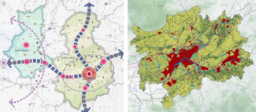
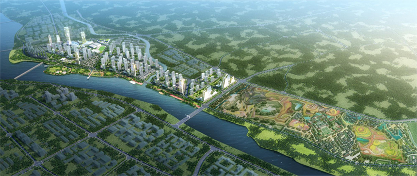
▲Upper planning
The downtown area of Shangrao was a small city in Xinzhou District developed at the intersection of Xinjiang and Fengxi Rivers before the county was removed and expanded. Since the beginning of reform and development, various industries and development zones in the city have actually been spread out in the lower reaches of the north bank of the Xinjiang River in Shangrao County to the west across the road from Chunjiang Avenue in the small main city. It is Shangrao’s common strategy to introduce industries and develop real estate along the river and across the river to the south. It is also a common phenomenon of disordered urban space immediately outside the administrative boundary of the central city before the county and city systems were straightened out;
Close to the urban area/but still within the scope of the county, real estate has unprecedented development, early land transfers are chaotic and disorderly, urban planning lags behind land transfers, and lags behind public supporting construction. Commercial residential districts are rapidly "planted" and savagely grown, but all kinds of public supporting services are seriously lagging behind; the keen sense of the real estate market has brought about the first land construction and the lagging planning, resulting in serious out-of-control features in important areas of the city. Waterfront area or wall-type high-rise residential walls, or urban landmark nodes that should have/public services are vacant;
The site of this project is located on the south side between the head of the Huzhouwei Bridge and the water conservancy gate valve, and the planned river-crossing bridge in the lower reaches of the city. The urban node land at the head of the Huzhouwei Bridge was passively transferred to real estate development in the absence of urban planning guidance in the early days. The construction of a row of high-rise real estate projects made the bridge head section lack the public features and signs that the city should have. sex.

Early suburban transit roads, power corridors and other infrastructures cut through the land at will according to the principles of their respective professions’ own convenience, resulting in extremely unfavorable conditions such as corridor duplication/low land utility/different-shaped plots, which brought great disadvantages to urban development and design. Great obstacle. These situations are also very typical in this project.
The land transfer model of "taking industrial orientation as an opportunity and supplemented by real estate development" will, in the past, present and foreseeable future in China, rise from invisible to dominant and gradually dominate the main theme of urban construction. The "property market" is actually a "policy market". It is a "birdcage economy" under the principle of "demanding from the virtual to the real" in the national macro policy, and shaking up and down within a limited range / acceptable to the public and enterprises. What is the definition of industry? The industry and planning designers in the eyes of development companies, as well as the connotations and extensions of industries defined by different levels of government, are very different.
All properties that cannot be sold or need to be operated belong to the "industry" of the development enterprise;
For the city government, is the supporting public infrastructure an "industry"?
For the governments above the city, should the content of the industry be outside the manufacturing industry, and should the scope of the service industry be controlled? How to control the severely vacant office and entrepreneurial space?
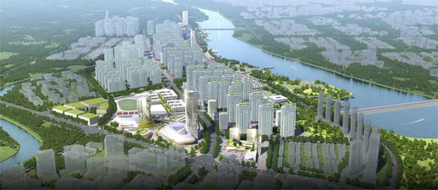
Jebsen Mengdu Digital Studio is located in Chengnan New District on the south bank of Xinjiang River. It is an urban area designed by Zhubo for overall planning. It is close to the main urban area and across the river from the old urban area. It is a pilot area to undertake the development of the main urban area across the river and has great development potential. The project strives to inject new vitality into Shangrao's urban development with differentiated "film and television industry and tourism". Through the development of tourism parks, promote the construction of urban infrastructure and supporting services; take the integration of industry and city as the core, link regional tourism resources, and shape new characteristics of urban tourism. Improve the quality of urban human settlements, introduce the population to feed back the tourism market, and try to explore a new mode of interaction and symbiosis between "themed tourism" and "urban development".
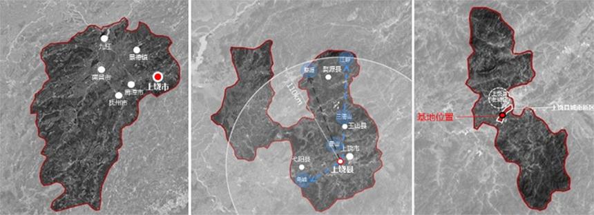
▲Location analysis
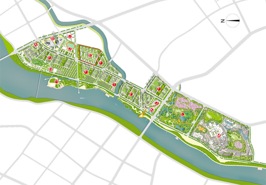
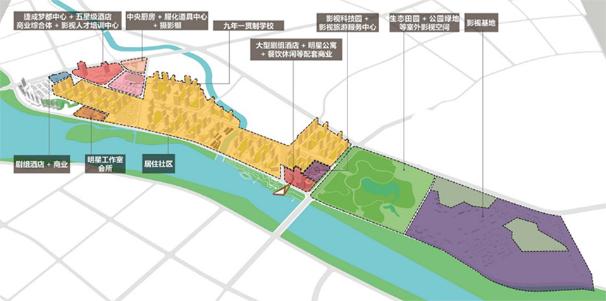
The planning and design proceeded from three main points: to create a brand-new city card for the city as a national demonstration project for the film and television cultural tourism industry, to provide tourists with innovative tourist destinations with distinctive film and television themes, and to create an emerging charm of industrial and city integration for the residents of the district. Small town. The spatial structure is dominated by "one axis, one belt and three cores": one axis represents the urban development axis of Avenue of Stars; one area represents the riverside urban life belt; the three cores represent the core of film and television tourism, film technology core, and film base core.
▲General floor plan
▲Functional division: function complex, theme penetration
Avenue of Stars Urban Development Axis: (New Model of Industry-City Integration) Based on the city, it will carry the industrial space and develop the industrial economy, and use the industry as the guarantee to drive urban renewal and improve service facilities. Riverside urban life belt: (Coordinated development of one river and two banks) Continuing the project's "New Waterfront City, Ecological and Livable" position in the south of the city to which the project belongs, and coordinating the development of the cities on both sides of the Xinjiang River.
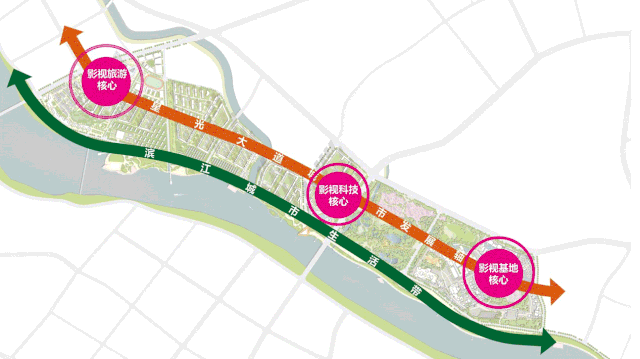
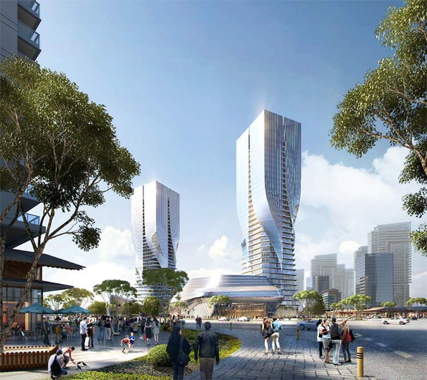
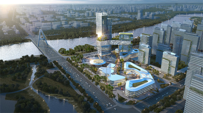
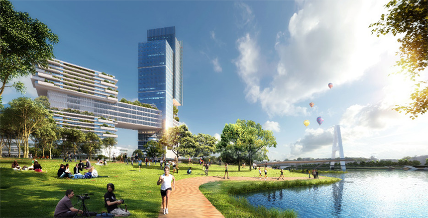
The core of film and television tourism:(the main cultural and tourism business section of the project) show the image of the project in the main traffic direction of the city, and shape the gateway landmark of the new urban area. Jebsen Dream Center, five-star hotel, theme commercial street, crew hotel, studio, service center.
The core of film and television technology:(the film and television industry sector) is the most advanced film and television technology center that integrates "R&D-display-experience-supporting" on the new bridge side of the southernmost part of the project. It is planned to build a tourism service center, film and television technology display, film and television post-production, film and television talent training; large-scale crew hotels, star apartments, catering and leisure and other supporting businesses.
The core of the film and television base:the construction of landscapes such as imperial cities, gardens, and gardens without specific dynasty logos between the Tang and Song Dynasties and the Ming and Qing Dynasties, and the construction of landscapes such as sea of flowers, woods, and artificial lakes to meet the needs of film crews and tourists.
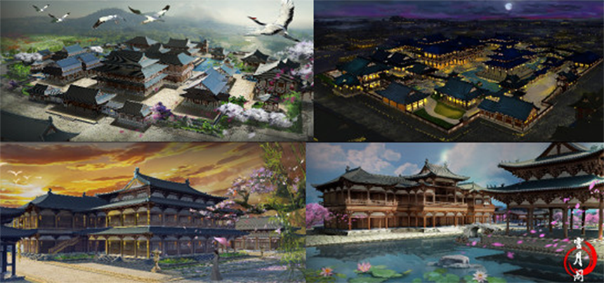
Through youthful and charming street scenes, commercial blocks with film and television entertainment themes, and complete public service facilities, build a dreamlike landscape and dream film and television city; through the pedestrian green corridors facing the water, multi-level group space, to achieve health Vibrant waterfront life, lively waterfront community business. Create a new film and television technology and cultural characteristic new zone integrating the four major functions of film and television industry, cultural scenic spots, tourism services and smart life, and build a world-class and domestic leading film and television cultural tourism demonstration industrial park.

Design company: Zhubo Design Co., Ltd.
Project address: Shangrao City, Jiangxi Province
Land area: 1.63 million square meters
Building area: 2.72 million square meters
Design year: 2018
Project status: To be built
Chief Architect of the Project: Yang Weizhong
Project design consultants: Chen Guangjun, Feng Guochuan, Zhang Chunliang
Project Chief Planner: Li Tao
Project design team: Peng Fang, Wang Yonggang, Guo Wenyao, Mou Hongwei, Qiao Xin, Gong Xiaodong
Project Owner: Shangrao City Jiecheng Mengdu Real Estate